

Actionable Intelligence for Weather-Driven Threats
SkyTL predicts extreme weather impacts, prevents avoidable losses and protects lives.
SkyTL is a multi-hazard platform that fuses sensor data, AI, and physics models to deliver real-time intelligence, helping decision-makers act faster and safer across floods, hurricanes, wildfires, and beyond.
Our Solutions
-
![Live wildfire risk map of California and Nevada showing active fire incidents with green circles indicating areas with active fires.]()
Visualize fire risk, detect wildfires quickly, and accurately forecast fire growth and threats.
-
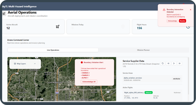
![Dashboard of an aerial operations system showing active aircraft, mission stats, drone command center, a map with boundary violation alert, mission planner, and service provider data.]()
Coordinate UAS and detect unwanted activity with real-time airspace intelligence.
-
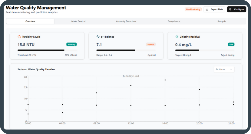
![Water quality management dashboard showing turbidity levels at 15.8 NTU, pH balance at 7.1, and chlorine residual at 0.4 mg/L with a 24-hour water quality timeline chart.]()
Predict water contamination risks and optimize treatment with real-time monitoring.
-
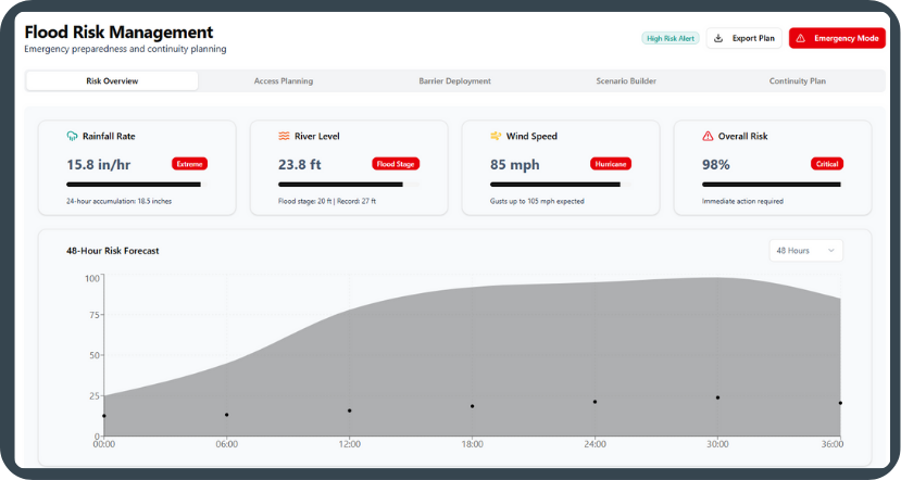
![Flood risk management dashboard showing rainfall rate of 15.8 inches per hour, river level at 23.8 feet, wind speed at 85 mph during hurricane, and overall risk at 98%, with a 48-hour risk forecast graph.]()
Monitor and predict storm surge and floods at the asset level with real-time mapping.

Technology Success Stories
Discover how our innovative solutions are making a real-world impact through cutting-edge technology, strategic partnerships, and life-saving applications.

May 2026
The innovative system monitors and detects changes in water quality at the Tampa plant at an early stage. Developed by ACCIONA in partnership with technology company SkyTL, the platform uses artificial intelligence and machine learning to analyze water data in real time, making it possible to predict critical parameters such as turbidity levels, salinity spikes, and red tide events at least two hours earlier than the plant’s conventional systems. This predictive capability makes it possible to anticipate incidents, optimize plant operations, and strengthen the water security of the region in question.
March 2025
SkyTL is partnering with Google to predict and combat wildfires.
July 2025
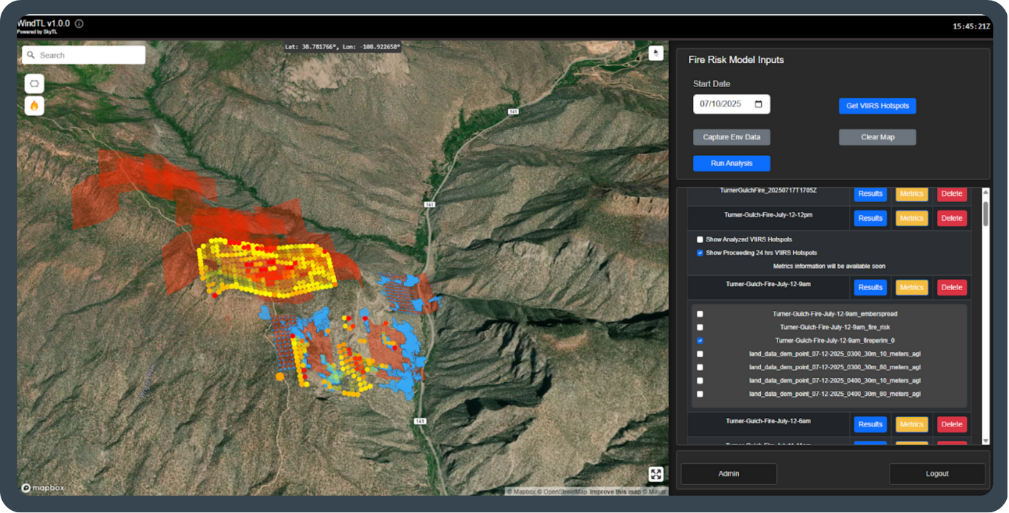
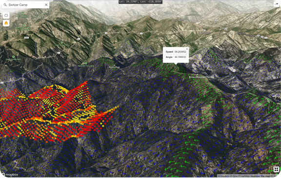
How WindTL pioneered the first commercial use of in-flight fire mapping to predict fire movement in real time, delivering critical wildfire intelligence with unprecedented speed during high-stakes wildfire events.
May 2025
Our platform enhanced coordination and tracking, greatly improving safety for emergency responders during complex rescues.
July 2024
WindTL forecasted the Thompson Fire’s ember jumping the rivers hours in advance.
Complete Disaster Response Lifecycle
From prevention to recovery, SkyTL’s multi-hazard platform supports every phase of disaster management.

Before Disaster Strikes.
Reduce risk through simulation, hazard mapping, and proactive mitigation strategies across multiple disaster types.
What-If Scenarios
Risk Mapping
Preventive Planning
Real-time alerts, evacuation guidance, and disaster spread predictions when every second counts for community safety.
During Active Events.
SMS Alerts
Evacuation Orders
Real-Time Tracking
Post Disaster Recovery.
Effective restoration project deployment, community rebuilding support, and grant assistance programs.
Recovery
Community Support
Grant Assistance
Backed by Leading Organizations


Ready to see SkyTL in action?
Experience how our platform empowers your organization with a personalized demonstration.