

Multi-Hazard Intelligence to Predict, Prevent, and Protect.
How SkyTL Works
Predict.
SkyTL fuses sensor data, AI, and physics models to forecast wildfires, floods, hurricanes, and other threats with unmatched accuracy.
Prevent.
With early intelligence, communities, utilities, and agencies can take proactive steps, from infrastructure hardening to evacuation planning, before disasters escalate.
Protect.
Real-time alerts, risk dashboards, and decision tools empower faster, safer responses that safeguard lives, assets, and critical infrastructure.
Multi-Hazard Solutions

Wildfire Intelligence.
Stay Ahead of the Flames
Every wildfire season, agencies face the impossible challenge of predicting how fast flames will spread, where embers will escape, and which communities are most at risk. Delays in intelligence often mean rushed evacuations, overwhelmed crews, and preventable losses. SkyTL provides real-time forecasts of fire spread, ember escape, and ignition potential. With this foresight, agencies can plan evacuations earlier, deploy resources more effectively, and make fireline decisions that save lives and protect communities.
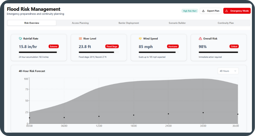
Flood and Storm Risk.
Flooding and severe storms can devastate communities in hours, overwhelming infrastructure and costing millions in recovery. Utilities, insurers, and local governments often lack the precision tools to anticipate storm surge, rainfall, and downstream impacts before disaster hits. SkyTL models storm surge, rainfall, and hydrologic flows at asset-level detail, enabling smarter prevention strategies, stronger infrastructure protection, and lower long-term costs..
Prepare for Rising Waters
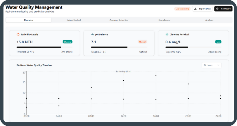
Water Quality Management.
Events like red tide, turbidity spikes, or changes in salinity can go undetected until they trigger costly shutdowns, environmental damage, or even public health crises. Traditional monitoring tools are too slow to catch these changes in time. By combining satellites, drones, sensors, and AI-driven analytics, SkyTL delivers early warnings on water quality shifts, helping utilities cut costs, prevent emergencies, and keep communities supplied with safe, reliable water.
Early Detection. Reliable Supply
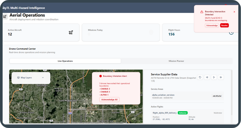
Aerial Operations.
During emergencies, aerial assets are often underutilized or poorly coordinated, leaving critical blind spots in disaster response. UAVs and drones can capture vital data, but without integration, decision-makers struggle to act on it in time. SkyTL unifies UAV feeds, mission management, and hazard intelligence, enabling faster, safer aerial operations that give responders the visibility they need when every second counts.