WindTL logo with stylized teal tree and the word WindTL in white capital letters.

PREDICT. PREVENT. PROTECT.

WindTL combines advanced modeling and real-time data to deliver fast, actionable insights for wildfire prediction and response.

The Wildfire Crisis is Accelerating

As climate change intensifies fire conditions worldwide, the cost of reactive responses continues to climb. Traditional forecasting lacks the precision and speed needed for effective prevention and response.

Plain white circle on black background
Warning icon with exclamation mark inside a triangle on a teal circular background

1 in 6 homes

In the US are now at risk of wildfire exposure

Icon of a globe showing continents in a simple graphic style.
A blank white circle with a black background.

+20% rise

In global wildfire frequency projected by 2050

White circle against a black background.
Green circular icon with a white map pin symbol in the center, representing location or map marker.
Empty white circle on a black background
Icon of three overlapping coins with dollar signs inside, symbolizing money or financial concepts.

90% of

homes lost in wildfires are due to ember spread

$893B

Estimated annual wildfire cost in the US

The WindTL Advantage

WindTL combines cutting-edge AI with proven fire science to deliver actionable intelligence when and where it matters most. Our platform transforms reactive firefighting into proactive fire prevention.

Traditional fire forecasting relies on delayed fire simulations that are mainly used for documenting decisions. WindTL provides real-time forecasts that can inform the very time critical decisions faced before and during a fire.

From Guesswork to Intelligence

  • Asset-Level Precision

    Dynamic risk assessments down to individual power lines, structures, and infrastructure

  • Severity Scoring

    Quantified risk metrics that distinguish routine high-risk from catastrophic potential

  • Proactive Alerts

    Early warning system enables preventive actions before ignition occurs

Text explaining AI-powered predictions using machine learning models trained on fire data to predict ignition probability and spread patterns with high accuracy, accompanied by a blue icon of a brain.
Screenshot of a mobile app or website describing 3D wind modeling for analyzing terrain effects on wind behavior and dangerous acceleration zones.
Icon of a lightning bolt inside a circle, with text describing real-time analysis using data from satellites, IoT sensors, and weather stations for up-to-the-minute situational awareness.
A digital screen displaying information about Ember Spread Prediction, highlighting its role in modeling ember dispersal to prevent structural damage.

Tailored Solutions for Every Stakeholder

WindTL serves the complete wildfire ecosystem, from first responders to property owners, with specialized tools designed for each unique use case.

Information poster for fire agencies and emergency response teams, including points on vegetation management, infrastructure risk assessment, resource deployment, and evacuation orders.
Slide from a presentation on utility companies' Power & Infrastructure, discussing proactive de-energization, predicting power line ignition probability, optimizing shutdowns, reducing liability, and maintaining service reliability.
Insurance website page with a green shield icon showing a check mark, titled 'Insurance Companies' and subtitle 'Risk Assessment & Pricing,' describing asset-level fire risk analysis for premium pricing and risk understanding.
Information about wildfire technology companies, including risk maps and fire monitoring capabilities, with a purple logo of buildings at the top.
Information on private properties for homeowners and businesses, including fire risk assessment, evacuation alerts, protection strategies, and real-time fire monitoring.

WindTL Success Stories

WindTL delivers real-time, AI-driven wildfire insights to help utilities, fire agencies, and insurers. Take a look at our most recent success stories.

July 2025

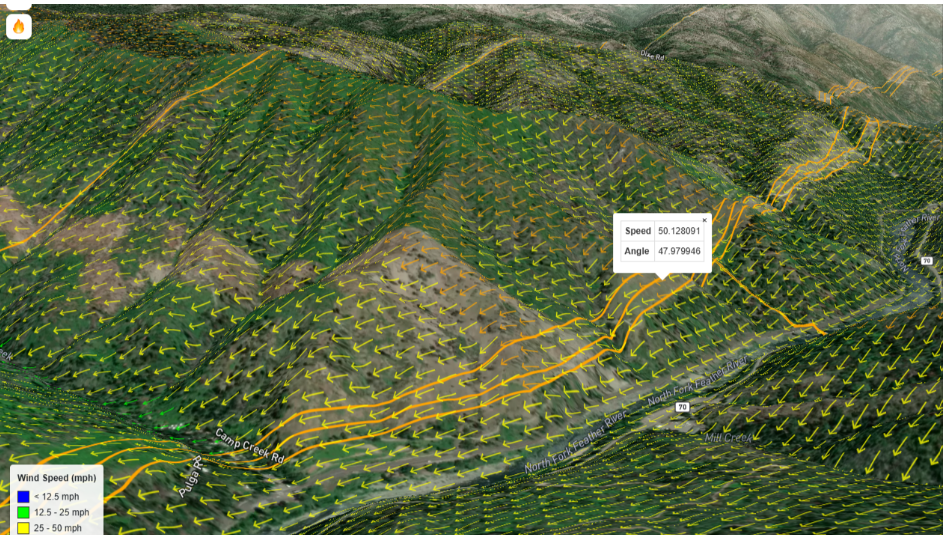
WindTL Predicts Fire Spread from Real-Time Aerial Mapping

How WindTL pioneered the first commercial use of in-flight fire mapping to predict fire movement in real time, delivering critical wildfire intelligence with unprecedented speed during high-stakes wildfire events.

Satellite map of a neighborhood with water risk overlays, fire risk points, and analysis controls on the right side.

March 2025

WindTL reconstructs fires to resolve disputes and guide future mitigation. 

A weather radar map showing precipitation levels over a region near Poinciana, Florida. The map features colored areas indicating rainfall intensity: green for light rain, yellow for moderate rain, and blue for heavy rain or a body of water, with a large blue lake visible in the upper right corner. The map also includes location labels, street names, and navigation controls.

June 2025

Fire spread and ember ignition risk modeled

Topographic map of a hilly, forested area showing wind vectors in yellow and orange, indicating wind speed and direction. The map includes roads labeled Camp Creek Road and Pulaski Road, with a data point showing a wind speed of 50.12 mph and an angle of 47.98 degrees.

July 2024

WindTL forecasted the Thompson Fire’s embers jumping the river hours in advance

How WindTL Could Have Changed the Camp Fire

The 2018 Camp Fire claimed 85 lives and caused $16.5 billion in damages. Here's how WindTL's technology could have prevented this catastrophe.

Text explaining the failure of a worn transmission line during Red Flag conditions, leading to a quick fire with little time for evacuation.

The Tragedy

Text slide titled 'The Problem' discussing the challenges of high risk warnings without asset-level specificity, lacking severity scoring, and limited fire spread prediction capabilities.

Infographic titled 'The Cost' displaying figures: 85 live lost, 19K structures, $16.5B in damages.

The WindTL Solution

A digital screen displaying emergency alerts about a wildfire near Pulga. The alerts include warnings of high severity risk zones, a flagged communication tower, a transmission line failure causing a campfire ignition, real-time forecast of rapid wildfire spread toward Paradise, and early evacuation orders with targeted shutoffs to prevent catastrophe.

"WindTL could have provided the clarity and confidence needed to act decisively."

Instead of being caught off guard, utility operators can execute a proactive plan that provides early warning about severe fire risk, enabling safer, more informed decisions.

Ready to See WindTL in Action?

Experience how our platform transforms wildfire response with a personalized demonstration tailored to your organization's needs.